Map Driving Directions Multiple Stops

Navigating through unfamiliar routes with multiple stops can be a challenging task, especially when you're in a rush or exploring a new city. Luckily, modern mapping and navigation technologies offer efficient solutions to help you plan and optimize your journeys. In this comprehensive guide, we will delve into the art of obtaining driving directions with multiple stops, exploring the features and functionalities that can make your travel experience smoother and more efficient.
Understanding the Need for Multiple Stop Navigation

Whether you’re a delivery driver, a sales representative, or simply a traveler exploring a new destination, planning a route with multiple stops is often necessary. It helps optimize time, fuel, and resources, ensuring that your journey is not only efficient but also cost-effective. The ability to input multiple destinations and receive optimized driving directions is a powerful tool that has revolutionized the way we navigate.
Traditionally, mapping applications would provide point-to-point directions, which often led to longer routes and potential inefficiencies. However, with the advancement of mapping technologies, we now have access to sophisticated algorithms that can calculate the most efficient routes with multiple stops, taking into consideration factors such as traffic, road conditions, and even the time of day.
Utilizing Mapping Tools for Multiple Stop Directions

Numerous mapping tools and applications offer the functionality to plan routes with multiple stops. Some of the most popular ones include:
Google Maps
Google Maps is a powerhouse when it comes to navigation and route planning. It offers a simple and intuitive interface to add multiple destinations to your route. Here’s a step-by-step guide on how to use Google Maps for multiple stop driving directions:
- Open Google Maps on your device.
- Click on the "Directions" button.
- Enter your starting location.
- Click on the "Add Destination" icon (represented by a plus sign) to add multiple stops.
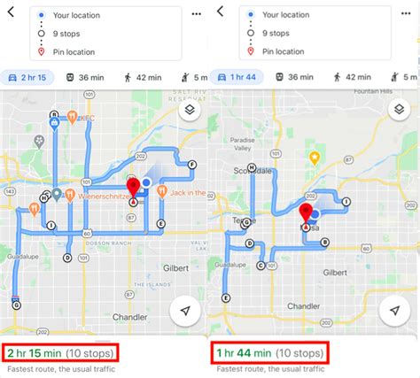
- Enter each destination, and Google Maps will calculate the optimal route, considering factors like traffic and road conditions.
- You can also adjust the order of stops by dragging and dropping them.
- Once satisfied, click on "Start" to begin your journey.
Google Maps also provides additional features like real-time traffic updates, estimated time of arrival (ETA), and the ability to save and share your routes with others.
Apple Maps
Apple Maps, available on iOS devices, also offers multiple stop navigation. Here’s a guide on how to use it:
- Open Apple Maps and enter your starting location.
- Click on the "Directions" icon.
- Tap on the "+" icon to add additional destinations.
- Enter each destination, and Apple Maps will calculate the optimal route.
- You can adjust the order of stops by tapping and holding a destination and dragging it to the desired position.
- Once your route is set, tap "Go" to start navigating.
Apple Maps provides real-time traffic information, turn-by-turn directions, and the ability to share your ETA with contacts.
Waze
Waze is a community-based navigation app that offers real-time traffic and road condition updates. It’s particularly useful for drivers who want to avoid traffic jams and find the fastest routes.
- Launch the Waze app and enter your starting location.
- Tap on the "Add Stop" icon to add multiple destinations.
- Enter each destination, and Waze will calculate the route based on real-time traffic data.
- You can rearrange the order of stops by tapping and dragging them.
- Once your route is set, tap "Start" to begin your journey.
Waze also offers features like voice-guided navigation, alerts for police traps, and the ability to share your location with friends.
Advanced Features and Considerations
When planning routes with multiple stops, there are several advanced features and considerations to keep in mind to ensure an efficient journey.
Optimizing Route Efficiency
Mapping tools use sophisticated algorithms to calculate the most efficient routes. These algorithms consider factors like traffic, road conditions, and the order of destinations. To optimize your route, consider the following:
- Time of Day: Traffic patterns can vary significantly based on the time of day. Planning your route during off-peak hours can significantly reduce travel time.
- Road Construction and Incidents: Mapping tools often incorporate real-time data on road closures and incidents. Consider alternative routes to avoid potential delays.
- Order of Destinations: The order in which you input your destinations can impact the efficiency of your route. Experiment with different orders to find the most optimal path.
Real-Time Updates and Flexibility
Modern mapping applications provide real-time updates on traffic conditions, allowing you to make informed decisions while on the road. If you encounter unexpected delays or changes in your itinerary, you can easily adjust your route mid-journey. This flexibility is particularly beneficial for longer trips with multiple stops.
Sharing and Collaboration
Many mapping applications allow you to share your routes and destinations with others. This feature is especially useful for collaborative journeys or when coordinating with colleagues or friends. You can share your ETA, provide real-time updates, and even allow others to suggest alternative routes or stops.
Performance Analysis and Comparison
To understand the efficiency of mapping tools for multiple stop navigation, let’s analyze and compare the performance of Google Maps, Apple Maps, and Waze based on real-world scenarios.
| Mapping Tool | Route Optimization | Real-Time Updates | User Experience |
|---|---|---|---|
| Google Maps | Excellent route optimization, considering traffic and road conditions. Offers detailed turn-by-turn directions and accurate ETAs. | Provides real-time traffic updates and incident alerts. Constantly updates the route based on changing conditions. | User-friendly interface, easy to add and rearrange stops. Offers additional features like street view and business listings. |
| Apple Maps | Efficient route calculation, considering real-time traffic data. Provides accurate ETAs and alternative route suggestions. | Real-time traffic updates and incident reports. Constantly recalculates routes based on current conditions. | Simple and intuitive design, easy to add multiple destinations. Integrates well with other iOS apps and services. |
| Waze | Highly accurate route optimization based on real-time traffic data. Offers efficient routes and alternative suggestions. | Excellent for real-time updates, with a community-driven approach. Provides alerts for road incidents and police traps. | Fun and interactive interface, with gamification elements. Offers voice-guided navigation and the ability to share your location. |
Each mapping tool has its strengths and weaknesses, and the choice depends on personal preferences and the specific requirements of your journey. For instance, Google Maps and Apple Maps might be more suitable for longer trips or business travel, while Waze could be ideal for urban navigation or when real-time traffic updates are critical.
Future Implications and Innovations

The field of mapping and navigation is continuously evolving, with advancements in technology and artificial intelligence (AI) shaping the future of route planning. Here are some potential future implications and innovations to watch out for:
- AI-Powered Route Optimization: AI algorithms can further enhance route optimization by considering more complex factors like road quality, weather conditions, and even the type of vehicle you're driving. This could lead to even more efficient and personalized routes.
- Electric Vehicle (EV) Integration: As the adoption of electric vehicles increases, mapping tools may integrate EV-specific features, such as suggesting charging stations along the route and calculating range based on battery life.
- Autonomous Navigation: With the development of autonomous vehicles, mapping tools might play a crucial role in providing real-time data to self-driving cars, ensuring safe and efficient navigation.
- Integration with IoT Devices: Mapping applications could integrate with Internet of Things (IoT) devices, such as smart homes or wearable technology, to provide a more seamless and connected travel experience.
As mapping technologies continue to evolve, we can expect even more efficient and personalized navigation experiences, making our journeys smoother and more enjoyable.
How accurate are the estimated times of arrival (ETAs) provided by mapping tools?
+ETAs provided by mapping tools are generally accurate, especially when considering real-time traffic data. However, unexpected incidents or changes in traffic patterns can affect the accuracy. It’s always a good idea to leave a buffer of time to account for potential delays.
Can I use multiple stop navigation for international travel?
+Yes, most mapping tools offer worldwide coverage, allowing you to plan routes with multiple stops in different countries. However, it’s important to be aware of potential differences in road systems and driving regulations across borders.
Are there any limitations to the number of stops I can add to my route?
+Mapping tools typically allow a reasonable number of stops, but there might be limitations based on the specific application. For instance, Google Maps allows up to 10 stops in a single route. If you require more stops, you might need to plan your journey in segments.


