How To Trace Route On Google Maps

Google Maps is an incredibly powerful tool that has revolutionized the way we navigate and explore the world. Beyond its basic navigation features, it offers a plethora of advanced functions, one of which is the "Trace Route" feature. This functionality provides an in-depth view of the journey from your current location to your destination, revealing every turn, street, and highway along the way. In this article, we will delve into the intricacies of how to utilize this feature effectively, explore its benefits, and discuss its real-world applications.
Understanding the Trace Route Feature

The Trace Route feature on Google Maps is a powerful tool that provides a detailed, step-by-step breakdown of your route. It offers a visual representation of your journey, highlighting every significant point along the way. This feature is particularly useful for those who want a comprehensive understanding of their travel path, whether it’s for personal navigation or professional purposes.
When you plan a route on Google Maps, the app calculates the most efficient path based on various factors like traffic conditions, road types, and speed limits. The Trace Route feature allows you to see this path in detail, making it easier to visualize and understand your journey.
Visualizing Your Journey
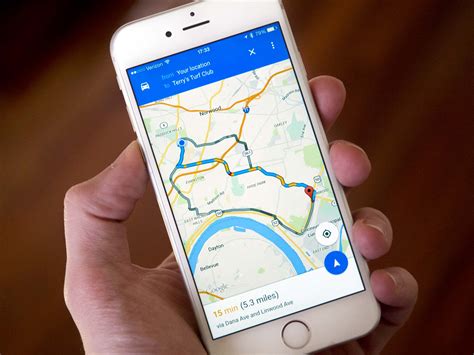
With the Trace Route feature, you can see your entire route on a single screen. It displays a colored line representing the path you’ll take, with each turn, intersection, and highway exit clearly marked. This visual representation is incredibly helpful for planning and executing your trip.
For instance, if you're planning a road trip, you can use the Trace Route feature to identify scenic routes, avoid potential construction zones, and even locate rest stops or gas stations along your way. It gives you a bird's-eye view of your journey, making it easier to anticipate any challenges or detours.
Benefits of Trace Route
The Trace Route feature offers numerous benefits to users. Firstly, it provides a detailed overview of your route, ensuring you’re well-prepared for your journey. By seeing every turn and exit, you can anticipate any potential delays or challenges, helping you plan accordingly.
Secondly, it's an excellent tool for those who are new to an area or are unfamiliar with the local roads. By visualizing the route, you can familiarize yourself with the layout and make more informed decisions during your trip. It reduces the chances of getting lost and provides a sense of confidence when navigating unfamiliar territories.
Lastly, the Trace Route feature is highly customizable. You can adjust your preferences, such as choosing the fastest route, the most economical one, or even a route that avoids highways. This flexibility allows you to tailor your journey according to your specific needs and preferences.
Step-by-Step Guide: How to Trace Route

Now that we understand the benefits and functionalities of the Trace Route feature, let’s dive into a step-by-step guide on how to use it effectively.
Step 1: Open Google Maps
The first step is to open the Google Maps app on your device. If you’re using a mobile device, ensure you have the latest version of the app installed. For desktop users, you can access Google Maps through your web browser.
Step 2: Plan Your Route
Once you’ve opened Google Maps, you’ll need to plan your route. Start by entering your starting location and your desired destination. You can do this by searching for an address, a landmark, or a specific point of interest.
After entering your destination, Google Maps will automatically calculate the most efficient route based on real-time traffic conditions and other factors. You'll see a blue line representing the suggested path.
Step 3: Access the Trace Route Feature
To access the Trace Route feature, simply tap or click on the blue line representing your route. This action will expand the route details, revealing a more comprehensive view.
On mobile devices, you may need to tap the "More" button or the three-dot menu icon to access additional route options. From there, you can select the "Trace Route" option.
Step 4: Explore Your Route
Once you’ve activated the Trace Route feature, you’ll be presented with a detailed view of your journey. The route will be displayed with color-coded segments, each representing a different part of your trip.
You can zoom in and out to get a closer look at specific sections of the route. This is particularly useful for identifying potential challenges, such as complex intersections or construction zones.
Step 5: Customize Your Preferences
Google Maps allows you to customize your route preferences. You can choose to prioritize the fastest route, the shortest route, or even a route that avoids highways. These preferences can be set before you plan your route or adjusted afterward.
To customize your preferences, tap or click on the settings icon (usually represented by a gear or a three-dot menu) and select your desired options. You can also adjust these settings while exploring your Trace Route.
Step 6: Share Your Route
If you’re planning a trip with friends or family, you can easily share your route with them. Google Maps offers various sharing options, including email, text message, or even social media platforms.
To share your route, simply tap or click on the share icon (usually represented by a paper airplane or a person icon) and select your preferred sharing method. This feature is particularly useful when coordinating group trips or providing directions to others.
Real-World Applications
The Trace Route feature on Google Maps has numerous real-world applications that benefit both individuals and businesses.
Personal Navigation
For everyday users, the Trace Route feature is an invaluable tool for personal navigation. Whether you’re commuting to work, exploring a new city, or embarking on a road trip, this feature provides a detailed, step-by-step guide to your destination.
By visualizing your route, you can anticipate potential delays, identify scenic routes, and make informed decisions about your journey. It takes the stress out of navigation and ensures you arrive at your destination confidently and efficiently.
Business Applications
Businesses can also leverage the power of the Trace Route feature to optimize their operations. For instance, delivery services can use this feature to plan efficient routes, minimizing travel time and maximizing productivity.
Logistics companies can utilize Trace Route to optimize their fleet management, ensuring that vehicles take the most efficient paths. This can lead to significant cost savings and improved customer satisfaction.
Emergency Services
Emergency services, such as ambulances, fire departments, and police, can benefit greatly from the Trace Route feature. By having a detailed view of the route, they can navigate quickly and efficiently to emergency scenes, potentially saving lives.
The Trace Route feature also allows emergency responders to anticipate potential challenges, such as road closures or construction zones, helping them plan alternative routes if needed.
Future Implications
The Trace Route feature on Google Maps is a testament to the advancements in navigation technology. As Google Maps continues to evolve, we can expect even more sophisticated features and improvements.
In the future, we may see more advanced route optimization algorithms that consider not only traffic conditions but also factors like road quality, weather conditions, and even real-time data from connected vehicles. This would result in even more accurate and efficient route planning.
Additionally, with the rise of autonomous vehicles, the Trace Route feature could play a crucial role in their navigation systems. It could provide detailed route information to self-driving cars, ensuring they navigate safely and efficiently.
Conclusion

The Trace Route feature on Google Maps is a powerful tool that enhances our navigation experience. It provides a detailed, visual representation of our journey, making it easier to plan and execute our trips. Whether you’re a daily commuter or a road trip enthusiast, this feature offers a wealth of benefits.
As we've explored, the Trace Route feature has applications beyond personal navigation. It can optimize business operations, improve emergency response times, and even contribute to the development of autonomous vehicles. With its versatility and constant improvements, Google Maps continues to be an indispensable tool for modern navigation.
Can I use the Trace Route feature offline?
+No, the Trace Route feature requires an internet connection to function. However, you can download maps for offline use, which will allow you to see your route without an active connection.
Is the Trace Route feature available on all devices?
+Yes, the Trace Route feature is available on both mobile devices (Android and iOS) and desktop computers. However, the user interface and exact steps to access the feature may vary slightly between platforms.
Can I use the Trace Route feature for international travel?
+Absolutely! Google Maps supports navigation in many countries worldwide. You can use the Trace Route feature to plan your routes, whether you’re traveling domestically or internationally.


