Create A Driving Route On Google Maps

Planning a driving route on Google Maps is an essential skill for anyone who frequently travels, whether for business or leisure. With its user-friendly interface and extensive database of locations, Google Maps offers a powerful tool to streamline your journeys, save time, and explore new destinations. In this comprehensive guide, we'll delve into the process of creating a driving route on Google Maps, covering everything from basic navigation to advanced route planning and optimization techniques.
Getting Started: Basic Route Planning

Creating a driving route on Google Maps is a straightforward process that can be accomplished in a few simple steps. First, ensure you have access to the Google Maps app on your mobile device or web browser. Here's how to get started:
- Open the Google Maps app or visit maps.google.com on your web browser.
- Enter your starting location. This can be your current location (if you allow Google Maps to access your device's location) or a specific address, city, or landmark.
- Click or tap on the "Directions" icon, typically represented by a diagonal arrow on the top-left corner of the screen.
- In the search bar, enter your destination. Google Maps will suggest destinations based on your search history and popular locations.
- Select the appropriate mode of transportation from the options provided. For driving routes, choose the "Car" icon.
- Google Maps will generate a suggested route based on real-time traffic data and your preferred navigation options. You can customize the route by dragging the route line on the map to adjust the path.
Once you've set your starting point and destination, Google Maps provides an estimated travel time, distance, and step-by-step directions for your journey. It's worth noting that Google Maps considers factors like traffic conditions, road closures, and construction sites when calculating the estimated time of arrival (ETA), ensuring you receive the most accurate and up-to-date information.
Advanced Route Planning: Optimizing Your Journey

While the basic route planning feature on Google Maps is convenient for everyday use, advanced route planning offers more flexibility and control over your driving experience. Here's how to take advantage of these features:
Adding Multiple Destinations
If you have multiple stops along your journey, Google Maps allows you to add them to your route. This feature is particularly useful for errands, deliveries, or sightseeing trips with multiple destinations.
- After setting your starting point, click on the "Add destination" button, usually located below the search bar.
- Enter each destination in order, and Google Maps will optimize the route to minimize travel time and distance.
- You can also drag and drop destinations on the map to rearrange their order or adjust the route manually.
Optimizing for Specific Preferences
Google Maps offers several options to customize your driving route based on your preferences. These include:
- Avoid Tolls: If you prefer to avoid toll roads or bridges, enable this option to have Google Maps suggest alternative routes.
- Avoid Highways: For a more scenic or leisurely drive, you can choose to avoid highways and take local roads instead.
- Traffic-Based Routing: By default, Google Maps considers real-time traffic data when calculating routes. However, you can disable this feature if you wish to avoid potential delays due to traffic.
- Time of Day: Google Maps can also optimize your route based on the time of day. For example, if you're planning a late-night drive, it may suggest a different route than during peak traffic hours.
Exploring Alternative Routes
Sometimes, you may want to explore alternative routes to compare travel times and distances. Google Maps provides this option, allowing you to evaluate different paths to your destination.
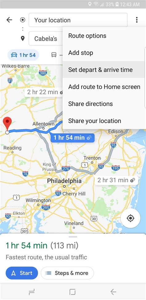
- Click on the three dots or the "More" icon in the top-right corner of the screen.
- Select "Alternate routes" from the menu.
- Google Maps will display up to three alternative routes, each with its estimated travel time and distance.
Using Google Maps for Navigation
Once you've planned your driving route, Google Maps provides comprehensive navigation tools to guide you along your journey. Here's how to make the most of its navigation features:
Real-Time Updates
Google Maps continuously updates your route based on real-time traffic and road conditions. If there's an incident or congestion on your planned route, it will suggest an alternative path to save you time.
Turn-by-Turn Directions
Google Maps offers clear and concise turn-by-turn directions, complete with visual cues and spoken instructions. This feature is particularly useful when driving in unfamiliar areas or during long-distance trips.
Lane Guidance
As you approach an intersection or highway exit, Google Maps provides detailed lane guidance to help you navigate complex interchanges or intersections smoothly.
Speed Limit Alerts
Google Maps can alert you to changes in speed limits along your route, helping you stay within legal limits and avoid unnecessary tickets.
Live Traffic Conditions
Google Maps displays real-time traffic conditions on your route, highlighting areas of congestion and potential delays. This information is invaluable for planning your journey and adjusting your arrival time accordingly.
Performance Analysis: Evaluating Your Route
After completing your driving route, Google Maps provides a performance analysis of your journey. This feature offers valuable insights into your driving habits and can help you optimize future trips.
Trip Statistics
Google Maps displays detailed statistics for your trip, including the total distance traveled, the duration of the journey, and the average speed. This information can be useful for expense reports, fuel efficiency calculations, or simply understanding your driving patterns.
Route Recap
Google Maps provides a recap of your route, showing the path you took and any notable landmarks or points of interest along the way. This feature is especially helpful for recalling specific locations or sharing your journey with others.
Traffic Impact Analysis
Google Maps analyzes the impact of traffic on your route, showing how much time was saved or lost due to congestion. This data can help you plan future trips more efficiently and avoid peak traffic hours.
Future Implications: Staying Up-to-Date with Google Maps

Google Maps is constantly evolving, with regular updates and improvements to its features and data. Staying up-to-date with these changes can enhance your driving experience and ensure you have access to the latest information.
Regular Updates
Google Maps receives frequent updates, including new features, improved data accuracy, and bug fixes. Ensure you have the latest version of the app or browser extension to take advantage of these improvements.
Real-Time Traffic Data
Google Maps relies on real-time traffic data to provide accurate ETAs and route suggestions. This data is continuously updated, ensuring you receive the most current information about road conditions.
Exploring New Features
Google Maps introduces new features regularly, such as augmented reality navigation, lane-level guidance, and improved voice commands. Stay informed about these features to enhance your driving experience and discover new capabilities.
Community Contributions
Google Maps allows users to contribute to its database by reporting issues, suggesting edits, and providing feedback. By actively participating in the community, you can help improve the accuracy and completeness of the map data, benefiting all users.
Integrating with Other Services
Google Maps integrates seamlessly with other Google services, such as Google Assistant, Google Search, and Google Earth. These integrations enhance your overall experience, allowing you to access map data and navigation features across various platforms and devices.
Conclusion
Creating a driving route on Google Maps is a straightforward process that offers numerous benefits for travelers. From basic route planning to advanced optimization techniques, Google Maps provides a powerful tool to streamline your journeys and explore new destinations. By leveraging its real-time data, customizable preferences, and comprehensive navigation features, you can make the most of your driving experiences.
Stay tuned for future updates and continue to explore the ever-evolving world of Google Maps to enhance your travels and discover new adventures.
Can I use Google Maps for international travel?
+Absolutely! Google Maps supports international travel and provides navigation and routing for a vast number of countries worldwide. However, it’s essential to check the availability of real-time traffic data and accurate map information for your specific destination.
How accurate is Google Maps’ estimated time of arrival (ETA)?
+Google Maps’ ETA is generally accurate, especially when considering real-time traffic data. However, unexpected incidents, road closures, or extreme weather conditions can affect travel times. It’s always a good idea to leave a buffer of time for potential delays.
Can I save my favorite routes for future use?
+Yes, you can save your favorite routes by clicking on the “Save” icon in the bottom-right corner of the route information card. This allows you to access your saved routes quickly and conveniently for future trips.
Does Google Maps offer pedestrian and cycling routes as well?
+Absolutely! Google Maps provides routing options for pedestrians, cyclists, and even public transportation. Simply select the appropriate mode of transportation from the options provided to access these specialized routes.
Can I share my driving route with others?
+Yes, you can share your driving route with others by clicking on the “Share” icon in the top-right corner of the route information card. This allows you to send the route via text, email, or social media, making it easy to coordinate trips with friends or family.


